If you look for Prussia on a map of Europe, you won’t find it. It’s gone. In the 18th century, however, it was very much there, and growing.
This map illustrates Prussia’s expansion before, during, and after the Versailles Century (1682-1789).
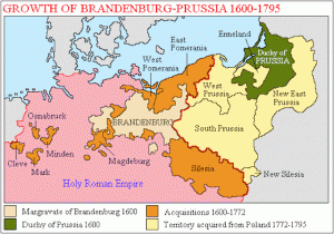
Map of Prussia, 1600-1795. Credit: Wikipedia.
In the beginning, two different branches of the House of Hohenzollern ruled Brandenburg (centre) and Prussia (right, in green). The Margrave of Brandenburg, as you might remember from the previous post, was one of the 9 electors empowered to select the Holy Roman Emperor. He was generally called the Elector (German: Kurfürst) of Brandenburg. Berlin was his capital. Prussia up to the mid-17th century was a vassal duchy of Poland. Its capital was Königsberg, nowadays known as Kaliningrad. In 1618, the Elector of Brandenburg married his last surviving Prussian cousin, the Duchess Anna, and henceforward the two states were in personal union. In other words, the same man was both Elector of Brandenburg and Duke of Prussia, but the two states were administered separately. A similar situation happened in Britain, with the personal union of England and Scotland after the death of Elizabeth I and the accession of James VII of Scotland as James I of England.


